Touring the River of Death

Yesterday, I took Jennifer’s dad to the Chickamauga Battlefield National Park. Over the years, I have visited there several times and I have read extensively about the battle. But, in the last decade I had not been there and had given it little thought.
It was nice to delve into the battle again.
Located less than an hour from my home, Chickamauga was the second bloodiest battle of the War Between the States – after Gettysburg. Out of roughly a total of 125,000 troops engaged in the vicious fighting about 35,000 were killed, wounded, or ended up missing. Far more casualties than Americans suffered on D-Day.
Popular history has it that Chickamauga means "river of death" in Cherokee. Jennifer’s dad had never been to the battlefield so I thought it would be a nice treat for him as part of his birthday. We have a shared interest in military history.
He seemed to genuinely enjoy the trip. We spent about two and a half hours on the battlefield. We took the basic driving tour and I talked about everything I could remember about what was happening on which day as we ventured through the battlefield.
Although there was heavy fighting on September 19, the driving tour really focuses on the more decisive second day of the battle. On that day Union General William Rosecrans made a mental blunder just as General James Longstreet attacked the hole conveniently placed in the Union line by Rosecrans ordering Thomas J. Wood’s Division out of line to patch another part of the Union line that was, in fact, solid. Though Longstreet planned his attack well, the fact he hit the hole in the Union line was pure coincidence.
We stopped to see the part of the Union line where the mix-up occurred. All the monuments helped us get a feel for where everyone was and how the fighting and movements took place. Early spring is a great time to go to Chickamauga because you can still see through the woods to monuments that will be hidden in foliage in a few more weeks.
 Chickamauga is also one of the first Civil War National Park’s. There are many, many monuments on the battlefield, some placed there by the actual participants in their old age. The locations are very exact and the Park Service has kept the woods and fields basically covering the same area as they did at the time of the battle.
 Chickamauga is an excellent preservation of a bloody American historical event. If you know the story you can see with your mind’s eye how it unfolded.
We went over to the extreme Union right flank which was protected by John Wilder’s Cavalry Brigade. This was the only brigade-sized unit to be fully armed with Spencer repeating rifles in the US Army in 1863. There were many regiments with repeating guns in the northern ranks. But, Wilder was the first brigade. In 1864, it became common for the US to arm cavalry brigades with repeaters, particularly in the Army of the Potomac.
To stop for a moment and get really geeky in a hawkish sense...The standard was for every fourth man to hold the horses of the other three in a dismounted cavalry attack. What Wilder did on the afternoon of September 20, 1863 was to attack a Arthur Manigault's Brigade. Seeing the breakthrough of the Union line, Wilder attacked the charging Confederates by riding a distance of about 1,000 yards. He then dismounted his 2,000 men, put rifles into 1,500 while the other 500 held the horses and fired seven rounds rapidly into the Confederate line before most of the Rebels got two shots back at them. They attacked like yellow jackets, causing great casualties while receiving few. Wilder then remounted and rode back to the height and reloaded. There was no secondary attack. Wilder had inflicted enough chaos into Longstreet's men that they could no longer catch the retreating Yankees in the open field.
We climbed up the 85-foot Wilder Memorial tower and got a scenic overview of where much of the fighting took place. Wilder was positioned on a rise behind a small ravine overlooking Glenn Field, a very large open area where a lot of back and forth fighting took place. I acknowledged this on a beautiful sunny, clear spring day. It was about 11 AM at that time, temperature was in the high seventies headed to the mid-eighties. Felt great.
Then we headed over to Snodgrass Hill where General George Thomas cobbled together a steady line that held off late day Confederate assaults and protected the part-rout, part-retreat of the beaten Union Army. Along the way I was telling Jennifer’s dad about General John Bell Hood being wounded in the arm at Gettysburg and then in the leg less than three months later at Chickamauga. I tried to recall where Hood was wounded on the battlefield but we missed it driving through. We decided to ask a ranger later about it. Along the way to Snodgrass we saw the South Carolina monument overlooking Dyer Field.
On Snodgrass we hiked a short distance over to a nice looking monument which turned out to be the 2nd Minnesota Regiment. The hill is filled with markers and monuments. There are even some markers showing specifically where some regiments ended and other began through the Union side of the line. The Confederate line lies in the woods and is dotted with small monuments marking the “high-tide” for specific regiments in the southern attack for the day.
I was disappointed we had missed where Hood was wounded. So, having completed the driving tour, we headed back to the visitor’s center and asked a very helpful young ranger to direct us to the location on the field. Turns out it was where I thought it was, back at the markers for Hood’s headquarters and Longstreet’s attack on the edge of Dyer Field. I was paying more attention at the time to the South Carolina monument in the distance.
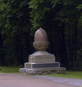
Anyway, we also inquired about the number of acorns we saw in the various Union 14th Corps markers and monuments. It was an influence from Union troops transferred west from the Virginia theater. The Army of the Potomac had adopted the policy in 1862 of designating each corps within it not only numerically but symbolically through various signs. The 14th Corps adopted an oak acorn. They did not rout from the field. They retreated in good order at the end of the day, again thanks to Thomas’ stand against Longstreet on Snodgrass Hill.
We backtracked to the southeast edge of Dyer Field. The distracting but commanding South Carolina monument is positioned in the northwest corner in the distance on the height. Here was the location of Hood’s Division headquarters. The initial Confederate attack on Snodgrass was repulsed and disintegrated into disorder. Hood was rallying and reorganizing his men on horseback when he was hit in the leg and removed from the line. The leg would later be amputated. Literally, John Bell Hood gave an arm and a leg in 1863 for the Lost Cause.
Jennifer’s dad was a bit tired and hungry at this point so he didn’t make the hike with me. He read interpretive markers along the roadside. The sign directing tour participants toward the marker about 200 yards into the woods is missing. The pole is there, but no sign. Anyway, there is a trail, easy to walk. I stood there on the edge of the woods for awhile. Looking out into the field and the bright clear sky on the edge of the treeline. There was no breeze.
We had a nice lunch in which I enjoyed a couple of strawberry ice teas then headed back home. I had to pick up some groceries and mow the yard yet. While mowing your mind drifts from thought to thought until, after awhile, you realize you weren’t thinking about anything at all for a moment there. No different from meditation. But, before I got to that moment when I wasn’t thinking about anything, I was thinking about the day and about Chickamauga.
It is wonderful to live in a nation that has some appreciation for special places. I didn’t watch the Ken Burns series on it, but I think our National Park system is a wonderful idea. Public lands to preserve natural beauty and/or historic significance is America's best idea.
I was thinking of all the different times I’ve gone to Chickamauga at all my different ages. From my teens I’ve visited there 4 or 5 times, just not much recently. It is a serene space today, punctuated with icy cold historical and military interpretation. You can think about the battle in detail or you can let your eyes drift through the distance on top of Wilder’s tower, wondering what that peak is to the south and if that high plateau in the distance to the west is Lookout Mountain.
Note: I forgot to take my freakin' camera.


Comments